
Google Maps Just Changed Driving Forever: Everything You Need to Know About the New 3D Navigation Experience
Introduction
Google Maps 3D Navigation Digital maps have changed the way people travel. Whether you’re driving to work, taking a family road trip, or exploring a city for the first time, a navigation app has become one of the most valuable tools on any smartphone.
For millions of Americans, Google Maps is the first app they open before starting a journey. It provides turn-by-turn directions, live traffic updates, nearby businesses, estimated arrival times, and route suggestions—all within seconds. However, navigation technology is evolving rapidly, and Google’s latest update marks one of the biggest changes in years.
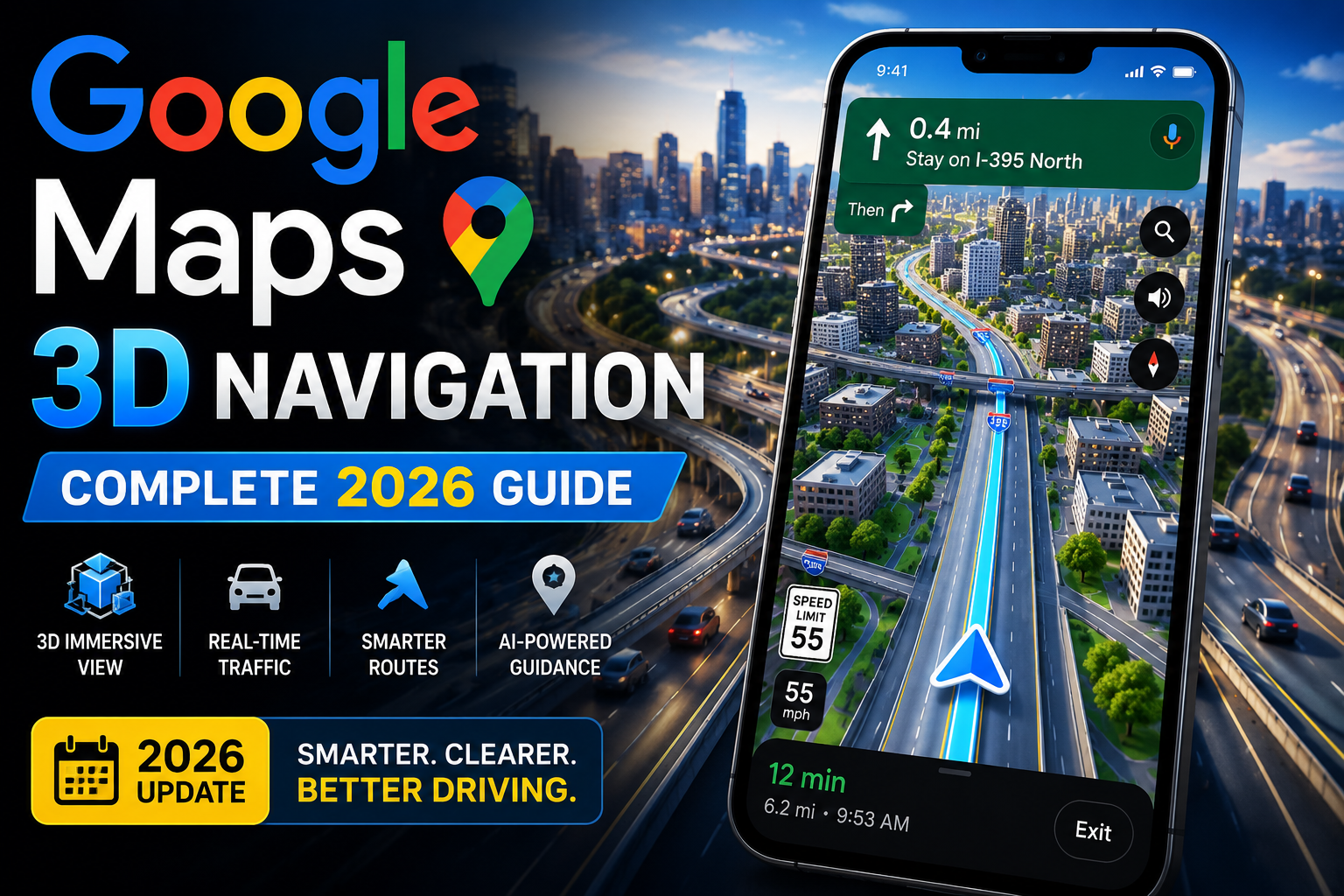
Instead of simply improving directions, Google is redesigning how drivers experience navigation. Its new Immersive Navigation introduces realistic 3D road visuals, smarter route guidance, AI-powered recommendations, and an interface designed to make complex roads easier to understand. The experience is rolling out gradually on supported devices and compatible Android Auto and CarPlay systems, beginning with users in the United States.
This isn’t just another visual redesign. It’s a shift toward navigation that mirrors the real world, helping drivers recognise roads, bridges, exits, and landmarks before they reach them.
Why Maps Matter More Than Ever
Digital maps have become much more than navigation tools.
Today they help people.
- Navigate unfamiliar cities
- Save time during daily commutes
- Avoid traffic congestion
- Discover restaurants and local businesses
- Find gas stations and EV charging locations
- Plan vacations
- Share live locations with friends and family
- Estimate travel times
- Explore new destinations confidently
Businesses also rely heavily on maps.
Delivery companies optimise routes to reduce fuel costs; rideshare drivers depend on accurate navigation; emergency services use mapping technology for faster response times; and tourists use digital maps to explore attractions without getting lost.
As our dependence on navigation grows, users expect maps to become smarter, faster, and more accurate.
The Challenge With Traditional Navigation
Despite years of improvements, traditional navigation still has limitations.
Most navigation apps display roads as flat lines on a screen.
While this works well for simple routes, it becomes difficult in areas featuring:
- Multi-level highways
- Large freeway interchanges
- Complex exits
- Overpasses
- Underpasses
- Service roads
- Dense downtown streets
Imagine approaching a busy freeway interchange with five different exits.
A flat map might show several overlapping lines, leaving you to quickly decide which lane to follow.
In heavy traffic, that uncertainty can lead to:
- Missed exits
- Sudden lane changes
- Extra travel time
- Driver stress
Google Maps 3D Navigation Google’s latest navigation experience is designed to reduce these situations by presenting roads in a more realistic way.
Introducing Immersive Navigation
Immersive Navigation is Google’s newest approach to digital maps.
Instead of relying primarily on traditional 2D graphics, the interface uses detailed three-dimensional visuals that better represent the road ahead.
Depending on compatibility and availability, users may notice:
- Three-dimensional buildings
- Elevated highways
- Flyovers
- Bridges
- Road elevation
- Terrain
- Trees
- Landmarks
- Improved lane visualization
Rather than simply displaying your route as a blue line, the system creates a clearer picture of the environment around you, making it easier to understand complicated road layouts. Google says the feature is designed to provide clearer guidance, show alternate route tradeoffs, and make navigation feel more natural.
From Reading Maps to Understanding Roads
Traditional navigation requires drivers to interpret symbols.
You see:
- Colored lines
- Small arrows
- Road names
- Distance markers
Then your brain converts those symbols into real-world driving decisions.
Immersive navigation reduces that mental effort.
Instead of imagining how an interchange looks, drivers can view a representation that closely resembles the actual road.
This creates a more intuitive experience, especially when navigating unfamiliar areas.
Why 3D Navigation Makes Sense
People naturally understand the world in three dimensions.
When driving, we recognise the following:
- Buildings
- Bridges
- Hills
- Trees
- Traffic signals
- Road elevation
Traditional maps remove much of that context.
By restoring some of these visual cues, modern navigation becomes easier to interpret.
For example, instead of wondering whether your exit is on the upper or lower roadway, a three-dimensional display helps you identify it more quickly.
The goal isn’t simply to make maps look better.
It’s to make them easier to understand.
Artificial Intelligence Is Transforming Maps
Another major part of Google’s latest update is artificial intelligence.
Modern maps no longer rely only on GPS signals.
They also analyse information such as the following:
- Live traffic conditions
- Historical driving patterns
- Road closures
- Construction updates
- Weather conditions
- Business information
- Anonymous traffic trends
Google is also introducing Gemini-powered features that allow users to ask more natural questions, receive personalised recommendations, and compare route options more effectively.
Instead of simply finding the shortest route, AI helps drivers choose routes that better match real-world conditions.
Why This Update Matters
Google Maps receives regular updates throughout the year.
Most improvements involve:
- Bug fixes
- Performance enhancements
- Updated road data
- Interface refinements
Immersive navigation is different.
It changes the way drivers experience navigation itself.
Some of the key improvements include:
| Traditional Maps | New Navigation Experience |
|---|---|
| Flat road display | Rich 3D road visualization |
| Basic route guidance | Smarter contextual guidance |
| Limited visual landmarks | Detailed environmental context |
| Standard lane directions | Improved lane awareness |
| Simple map view | Realistic driving perspective |
Together, these changes aim to reduce confusion while making navigation feel more intuitive.
Who Will Benefit Most?
The new navigation experience can benefit almost every type of driver.
Daily Commuters
Drivers who travel the same routes every day can receive smarter traffic predictions and alternate route suggestions.
Road Trip Travelers
Exploring unfamiliar destinations becomes easier when roads and landmarks are easier to recognise.
Delivery Professionals
Accurate routing and improved road visualisation can help reduce delays and improve efficiency.
New Drivers
People with limited driving experience may feel more confident navigating busy intersections and complex highway systems.
Electric Vehicle Owners
As charging infrastructure expands, maps are becoming increasingly useful for locating nearby charging stations and planning longer trips.
Google Maps 3D Navigation Inside Google Maps’ New Navigation Experience — Features, AI, and Smarter Driving
How Modern Maps Work Behind the Scenes
Most people open Google Maps, type a destination, and begin driving without thinking about the technology that powers the experience. Behind every route recommendation, however, is a sophisticated system that processes enormous amounts of information in real time.
Unlike older GPS devices that simply calculated the shortest distance, today’s maps combine data from multiple sources to provide faster, safer, and more reliable directions.
These sources include:
- GPS satellites
- Road network databases
- Live traffic information
- Historical traffic patterns
- Road construction updates
- Weather conditions
- Anonymous location signals
- Artificial intelligence (AI)
- Cloud computing
Every few seconds, the system checks whether conditions have changed. If traffic builds unexpectedly or a road closes, the route can automatically adjust to help drivers avoid delays.
This constant analysis is one of the reasons why modern navigation feels much smarter than it did just a few years ago.
What Makes Immersive Navigation Different?
Most navigation apps have traditionally shown roads from a top-down perspective.
While effective, that approach requires drivers to mentally translate flat graphics into the real world.
Immersive Navigation aims to bridge that gap.
Instead of simply highlighting a blue route, it presents roads with greater depth and environmental detail, helping drivers understand complex intersections before they reach them.
Depending on device compatibility, users may see the following:
- Three-dimensional buildings
- Highway overpasses
- Bridges
- Flyovers
- Road elevation
- Lane layouts
- Surrounding landmarks
- Trees and terrain
These visual improvements aren’t just designed to make the map more attractive—they’re intended to help drivers make quicker, more confident decisions.
Smarter Lane Guidance
One of the biggest causes of driving frustration is discovering you’re in the wrong lane just moments before an exit.
This often happens when:
- Traffic is heavy
- Road signs are difficult to read
- Multiple exits appear close together
- Drivers are unfamiliar with the area
Enhanced lane guidance helps solve this problem by showing the preferred lanes earlier in the journey.
Instead of waiting until the last second, drivers receive clearer visual cues about the following:
- Lane positioning
- Highway splits
- Exit directions
- Merge points
- Upcoming turns
Preparing in advance reduces the need for sudden lane changes and helps create a smoother driving experience.
Better Route Planning With AI
Artificial intelligence has become one of the most important technologies behind modern maps.
Rather than simply calculating the shortest route, AI evaluates many variables before recommending the best option.
These include:
Current Traffic
The system analyses live traffic speeds across thousands of roads.
Historical Trends
It compares current traffic with patterns from previous days and times.
Road Conditions
Construction zones, temporary closures, and reported incidents are taken into account whenever possible.
Travel Time
Instead of focusing only on distance, AI estimates the fastest arrival based on real-world conditions.
User Preferences
Drivers can often choose to:
- Avoid toll roads
- Avoid highways
- Prefer fuel-efficient routes
- Select alternate routes
AI combines these preferences with current road conditions to generate more personalised navigation.
Live Traffic Updates in Real Time
Traffic conditions change constantly.
A highway that’s clear at 8:00 AM may become congested by 8:10 AM due to an accident or sudden increase in traffic volume.
Modern maps monitor these changes continuously.
They can detect:
- Traffic slowdowns
- Congestion
- Road closures
- Construction activity
- Accidents (where reported)
- Delays caused by major events
As conditions change, the estimated arrival time updates automatically, helping drivers make informed decisions throughout their journey.
Predictive Navigation
One of AI’s greatest strengths is its ability to recognise patterns.
Instead of reacting only after traffic appears, modern navigation systems increasingly predict delays before they happen.
For example, AI may anticipate congestion caused by:
- Morning rush hour
- Evening commutes
- Holiday travel
- Sporting events
- Concerts
- School schedules
- Weekend tourism
By identifying these patterns, the system can recommend alternate routes before traffic becomes severe.
A Better Search Experience
Maps are no longer just for directions.
People also use them to discover places.
In the past, searches were often very simple.
Examples included:
- Coffee shop
- Hotel
- Gas station
Today, users increasingly search using natural language.
Examples include:
- Best breakfast near me
- Family-friendly restaurants nearby
- Quiet coffee shop with Wi-Fi
- Parks that allow dogs
- Electric vehicle charging stations nearby
Artificial intelligence helps interpret these conversational searches and return more relevant results.
Richer Business Information
Google Maps has become one of the world’s largest local business directories.
Business listings often include the following:
- Customer reviews
- Photos
- Opening hours
- Contact details
- Popular visiting times
- Accessibility information
- Menus
- Booking links
This allows users to research destinations before arriving, reducing uncertainty and making trip planning more convenient.
Navigation on Android Auto
Many drivers prefer using Google Maps through Android Auto because it projects navigation onto the vehicle’s infotainment display.
Advantages include:
- Larger screen
- Easier-to-read directions
- Voice commands
- Hands-free operation
- Better visibility while driving
The new navigation interface is designed to take advantage of these larger displays by presenting richer road visuals without cluttering the screen.
For compatible vehicles, this creates a navigation experience that’s both informative and easier to follow.
Voice Guidance That Feels More Natural
Visual improvements are important, but spoken directions remain essential.
Modern navigation systems are becoming more conversational by providing guidance that matches how people naturally give directions.
Examples include:
- “Stay in the two left lanes.”
- “Keep right toward Downtown.”
- “Take the second exit at the roundabout.”
These instructions are often easier to understand than directions based only on street names.
Designed for Different Types of Travel
Google Maps isn’t just built for drivers.
It supports several travel modes, including:
Walking
Pedestrian directions can help users navigate sidewalks, crossings, and city streets.
Cycling
Cyclists can receive routes that prioritise bike-friendly roads where available.
Public Transportation
Many cities provide transit information such as the following:
- Bus routes
- Train schedules
- Subway connections
- Transfer points
This makes maps useful even for people who don’t drive regularly.
Traditional Navigation vs. Immersive Navigation
| Feature | Traditional Navigation | Immersive Navigation |
|---|---|---|
| Road View | Flat 2D display | Detailed 3D visualization |
| Lane Guidance | Standard | Enhanced lane awareness |
| Landmarks | Limited | Rich environmental context |
| Traffic Analysis | Live updates | Live + predictive insights |
| Route Planning | Basic optimization | AI-assisted recommendations |
| User Experience | Functional | More intuitive and realistic |
Benefits for Everyday Drivers
The latest navigation improvements can make a noticeable difference in many real-world situations.
For example:
During Daily Commutes
AI can identify developing traffic and suggest alternate routes before delays become significant.
On Long Road Trips
Detailed road visualisation helps drivers navigate unfamiliar highways more confidently.
In Busy Downtown Areas
Recognisable landmarks and improved lane guidance reduce confusion at complicated intersections.
For Delivery Drivers
Accurate routing and smarter traffic predictions can improve efficiency and reduce travel time.
For Families
Parents can quickly locate restaurants, gas stations, parks, hotels, and rest areas while travelling.
Google Maps 3D Navigation: Google Maps vs. Other Navigation Apps, Real-World Benefits, and the Future of Smart Maps
Google Maps 3D Navigation: Google Maps vs. Other Navigation Apps
The navigation app market has become increasingly competitive over the past decade. While Google Maps remains one of the most popular choices, several other platforms offer unique features for different types of users.
Choosing the right app depends on your priorities, whether that’s live traffic updates, offline navigation, community alerts, or seamless integration with your smartphone.
Here’s how some of the leading navigation apps compare.
| Feature | Google Maps | Waze | Apple Maps | HERE WeGo |
|---|---|---|---|---|
| Live Traffic | Excellent | Excellent | Very Good | Good |
| Offline Maps | Yes | Limited | Yes | Excellent |
| Business Listings | Excellent | Good | Very Good | Good |
| Android Auto | Yes | Yes | No | Yes |
| Apple CarPlay | Yes | Yes | Yes | Yes |
| EV Charging Support | Excellent | Good | Very Good | Moderate |
| Public Transit | Excellent | Limited | Very Good | Good |
| Walking & Cycling | Excellent | Good | Very Good | Good |
| AI-Powered Features | Advanced | Moderate | Growing | Limited |
Each platform has its strengths, but Google Maps stands out because it combines navigation, local business discovery, public transportation, and AI-assisted search into a single app.
Why Millions of People Choose Google Maps
Google Maps has become the preferred navigation platform for many users because it offers much more than driving directions.
Some of its biggest strengths include:
Extensive Business Information
Users can instantly access the following:
- Customer reviews
- Photos
- Business hours
- Contact details
- Website links
- Popular visiting times
- Accessibility information
This makes it easy to decide where to eat, shop, or stay without leaving the app.
Frequent Map Updates
Road networks change constantly.
Every year, cities add:
- New highways
- Bridges
- Residential streets
- Roundabouts
- Traffic signals
Construction projects also create temporary road closures and detours.
Google Maps updates its mapping data regularly, helping users navigate with more current information.
Cross-Platform Compatibility
Google Maps works across almost every major device.
Supported platforms include:
- Android smartphones
- iPhones
- Tablets
- Web browsers
- Android Auto
- Apple CarPlay
- Smartwatches (supported models)
This flexibility allows users to plan a trip on one device and continue it on another.
Real-World Driving Scenarios
Technology becomes most valuable when it solves everyday problems.
Let’s look at how modern maps help in common driving situations.
Morning Commute
Suppose your normal commute takes 35 minutes.
Halfway through your journey, an accident blocks several lanes on the highway.
Instead of leaving you stuck in traffic, Google Maps can:
- Detect the slowdown
- Calculate alternate routes
- Estimate the time savings
- Suggest whether rerouting is worthwhile
This helps drivers avoid unnecessary delays and arrive at work on time.
Airport Drop-Off or Pickup
Airports are often among the most confusing places to drive.
Drivers may encounter:
- Multiple terminals
- Separate arrival and departure roads
- Parking garages
- One-way traffic systems
- Temporary lane changes
Enhanced road visualisation helps drivers identify the correct approach more confidently.
Exploring a New City
When visiting an unfamiliar city, people often wonder the following:
- Which road should I take?
- Where is the parking entrance?
- Which street is one-way?
- Where is the main entrance to the building?
Modern maps provide richer context through landmarks, detailed road layouts, and local business information, making navigation less stressful.
Long-Distance Road Trips
Road trips involve much more than reaching a destination.
Travellers often need to locate the following:
- Hotels
- Restaurants
- Gas stations
- Rest areas
- Tourist attractions
- Scenic viewpoints
- Electric vehicle chargers
Instead of switching between multiple apps, Google Maps allows users to discover many of these places while planning or following a route.
Benefits for Different Types of Users
Every driver has different needs.
The latest navigation improvements benefit a wide variety of users.
Daily Commuters
Commuters benefit from:
- Live traffic analysis
- Faster rerouting
- Accurate arrival estimates
- Predictive congestion alerts
Families
Parents often appreciate features that help locate the following:
- Family-friendly restaurants
- Parks
- Hotels
- Rest stops
- Grocery stores
- Medical facilities
Delivery Drivers
For professional drivers, efficient navigation directly impacts productivity.
Useful features include:
- Accurate addresses
- Traffic-aware routing
- Multiple-stop planning
- Business information
- Faster route adjustments
Business Travelers
Frequent travellers can quickly find the following:
- Airports
- Conference centers
- Hotels
- Parking garages
- Rental car services
- Nearby restaurants
Electric Vehicle Owners
As EV adoption grows, navigation apps play an increasingly important role in trip planning.
Maps help drivers locate:
- Fast chargers
- Public charging stations
- Compatible charging networks
- Nearby amenities while charging
This reduces “range anxiety” and makes long-distance EV travel more practical.
Navigation Beyond Driving
Digital maps are useful for far more than driving.
Today they also support:
Walking
Pedestrian navigation includes:
- Sidewalk directions
- Crosswalk guidance
- Walking shortcuts
- Nearby attractions
Cycling
Cyclists can receive routes that prioritise the following:
- Bike lanes
- Dedicated cycling paths
- Lower-traffic roads
- Elevation information
Public Transportation
In many cities, Google Maps provides:
- Bus routes
- Train schedules
- Subway information
- Transfer guidance
- Estimated arrival times
This makes it a valuable tool even for people who don’t own a vehicle.
Current Limitations
Although navigation technology has improved dramatically, no mapping platform is perfect.
Drivers may still encounter situations such as:
- Recently closed roads
- Temporary construction
- GPS signal interruptions
- Incorrect business information
- Severe weather conditions
- Rural areas with limited mobile coverage
For this reason, drivers should always pay attention to road signs and changing conditions instead of relying solely on navigation instructions.
Google Maps 3D Navigation Tips for Using Google Maps More Effectively
To get the best experience from Google Maps, consider these practical tips.
Keep the app updated.
Regular updates improve:
- Navigation accuracy
- Performance
- Security
- Compatibility with new features
Download Offline Maps
Before travelling through remote areas, download maps in advance. Offline maps can be extremely useful when mobile service is unavailable.
Compare Route Options
Before beginning a trip, review alternate routes.
Sometimes a route that takes only a few extra minutes may offer the following:
- Less traffic
- Fewer tolls
- Easier driving conditions
- More predictable travel times
Use Voice Guidance
Voice navigation allows drivers to keep their eyes on the road instead of constantly checking the screen.
Mount Your Phone Securely
If your vehicle doesn’t support Android Auto or Apple CarPlay, use a dashboard mount that keeps the phone visible without obstructing your view.
The Future of Smart Maps
Navigation technology is moving beyond simply showing roads on a screen.
In the coming years, digital maps are expected to become even more intelligent through advancements such as:
- More realistic 3D environments
- Better AI-powered route planning
- Augmented reality walking directions
- Smarter voice assistants
- Improved electric vehicle support
- Enhanced traffic prediction
- Integration with connected vehicles
- More personalized travel recommendations
These innovations will make navigation faster, more intuitive, and better suited to each user’s individual needs.
Final Thoughts
The latest evolution of maps represents much more than a visual upgrade. By combining realistic 3D graphics, artificial intelligence, predictive traffic analysis, and enhanced route guidance, modern navigation is becoming an intelligent travel companion rather than just a digital roadmap.
Whether you’re commuting across town, planning a cross-country adventure, managing business deliveries, or simply searching for a nearby restaurant, today’s mapping technology helps make every journey more efficient and informed.
As these technologies continue to evolve, digital maps will play an even greater role in how people travel, explore, and connect with the world around them.